GoGreenRoutes Data Hub
The GoGreenRoutes Data Hub provides access to the NBS-related monitoring data gathered in the GGR Cultivating Cities.
These datasets are presented in the overall context of urban green in the cities. The Data Hub allows interested users to download these data sets.
Moreover, you can access the cities' local data portals, and thus the entire databases of the GoGreenRoutes Cultivating Cities, by clicking the links below.


GoGreen Routes Data Hub
Project data in the context of urban green distribution
Green space plays a major role within the GoGreen Routes project. The Cultivating Cities pioneer Nature-based Solutions and green infratructure like green corridors, parks and community gardens to improve urban residents' health and well-being. These initiatives maximize public space, encourage active lifestyles, and restore ecological areas. They also reduce pollution, enhance urban ventilation, provide habitat for various species, all while promoting residents' prosperity. All these aims are closely linked to the characteristics and the distribution of green space in the urban environment.
The GoGreen Routes Data Hub offers the Cultivating Cities a tool to visualize their urban green spaces, their respective proportions, and spatial distribution. This approach brings about the following advantages:
- The context for local NbS interventions by GoGreen Routes is outlined in a homogeneous way for all cities.
- Applying this concept across cities enables assessment and comparison of relevant environmental characteristics simultaneously.
- Small-scale NbS interventions, when replicated across multiple locations, yield significant effects at city-wide and regional scales. This systematic mapping approach illustrates these effects.
- The tool empowers city planners to make informed decisions by evaluating the impacts of existing NBS interventions and identifying areas in need of future interventions.
- Satellite-based data ensure unbiased and reliable information, fostering consistency.
- This tool has the potential to assess the effects of scaled-up NBS interventions even at the European level, aiding in the design of future project calls targeting NBS interventions.
Urban green classification
Eight classes of urban green (including water surfaces) were established based upon Copernicus Land Monitoring Service data (Urban Atlas and additional high-resolution layers).
Class | Description | Benefits | Data used and class description |
Forest | Forests play an essential role for several GoGreen Routes cultivating cities, e.g. 70% of Lahti is covered by forest. All our cities place emphasis on promoting outdoor activities in forests in their urban and suburban regions. | Forests contribute to air purification, urban temperature regulation, space for recreation and city biodiversity. They are also important for water regulation. | Copernicus Urban Atlas Woodlands with a vegetation pattern composed of native or exotic coniferous and/or broad-leaved trees, canopy closure with a minimum of 30 %. |
Green urban areas | Green spaces with the urban greenery of linear parks have been tested across the Cultivating Cities. Moreover, parks and general green urban areas form the basis for the new green corridors. | Parks provide area for recreation, contribute to urban temperature regulation and air purification. | Copernicus Urban Atlas Copernicus HRL Imperviousness OpenStreetMap Public green areas for predominantly recreational use including urban parks. |
Street trees | The agreed NBS framework of GoGreen Routes encompasses green infrastructure including additional street trees to enhance existing urban spaces to change public perception of mere roads towards greenways. | Street trees contribute to urban temperature regulation, air purification and provide a pleasant environment for people. | Copernicus HRL Small Woody Features Trees aligned with the streets and not included in parks |
Sport and leisure | Sports and outdoor activities in general are a cental point for GoGreen Routes attention and efforts. The project engages with sports clubs and other pertinent activities. Physical activity is a major element of the 360-Health approach. | Green sports and leisure facilities are relevant for people’s health, facilitating physical activity and also social interaction. | Copernicus Urban Atlas Copernicus HRL Imperviousness Areas used for sports, leisure and recreation. Camping grounds, sports grounds, leisure parks, golf courses, race courses, etc. |
Private gardens | Gardens play an important role in the Cultivating Cities of GoGreen Routes. For instance, Versailles has 1.17 ha of family and shared gardens and educates its citizens regarding sustaible gardening. | Private gardens provide a pleasant environment for people living there. But also have a general benefit contributing to air purification, biodiversity and regulating urban temperature. | Copernicus Urban Atlas Copernicus HRL Imperviousness Green areas inside residential areas. |
Allotments | Public gardening reconnects people to nature and more sustanable lifestyles. Community gardening is part of NBS interventions of the Cultivating Cities, e.g., Limerick fosters community gardening initiatives. | Alltoments improve the health facilitating physical activity, and greater social interaction and cohestion. | Copernicus Urban Atlas Copernicus HRL Imperviousness OpenStreetMap Parcels of land for growing vegetables |
High nature value farmland | The Cultivating Cities promote food from retail outlets along the green route and healthier food choice among citizens by local producers. Nutrition is also one of the corner stones of the 306-Health concept. | Those areas combine the provision of local food with favourable conditions for biodiversity. | EEA High nature value (HNV) farmland Biodiversity tied together with the continuation of farming on certain types of land and the maintenance of specific farming systems. |
Water | Water plays a major role in several Cultivating Cities, e.g. Umeå lies at the mouth of a river at the Baltic Sea, Burgas is situated between the Black Sea and the Burgas Lake. Areas close to water bodies are also essential greenways and green pathways through several Cultivating Cities. | Water is often included, complementing green areas. Blue infrastructure has cooling and recreational benefits as well. | Copernicus Urban Atlas Rivers, lakes, ponds |
Used Earth Observation data sources
The following data sources were used to construct the maps and bar-charts shown on the GGR data hub pages.

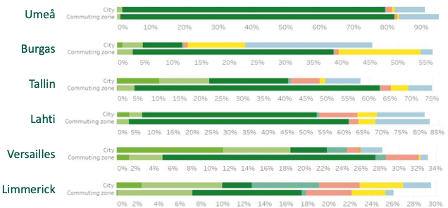
Comparing urban greenery in the Cultivating Cities
The characteristics of urban green spaces differ significantly among the Cultivating Cities, reflecting their unique ecological, geographical, and urban planning contexts.


